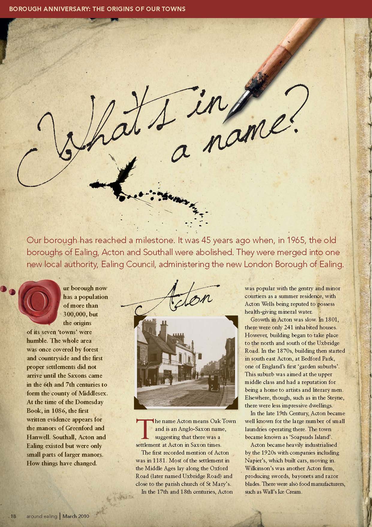
Our borough has reached a milestone. It was 45 years ago when, in 1965, the old boroughs of Ealing, Acton and Southall were abolished. They were merged into one new local authority, Ealing Council, administering the new London Borough of Ealing.
Our borough now has a population of more than 300,000, but the origins of its seven ‘towns’ were humble. The whole area was once covered by forest and countryside and the first proper settlements did not arrive until the Saxons came in the 6th and 7th centuries to form the county of Middlesex.
At the time of the Domesday Book, in 1086, the first written evidence appears for the manors of Greenford and Hanwell. Southall, Acton and Ealing existed but were only small parts of larger manors. How things have changed.
Acton
The name Acton means Oak Town and is an Anglo-Saxon name, suggesting that there was a settlement at Acton in Saxon times.
The first recorded mention of Acton was in 1181. Most of the settlement in the Middle Ages lay along the Oxford Road (later named Uxbridge Road) and close to the parish church of St Mary’s.
In the 17th and 18th centuries, Acton was popular with the gentry and minor courtiers as a summer residence, with Acton Wells being reputed to possess health-giving mineral water.
Growth in Acton was slow. In 1801, there were only 241 inhabited houses. However, building began to take place to the north and south of the Uxbridge Road. In the 1870s, building then started in south east Acton, at Bedford Park, one of England’s first ‘garden suburbs’. This suburb was aimed at the upper middle class and had a reputation for being a home to artists and literary men. Elsewhere, though, such as in the Steyne, there were less impressive dwellings.
In the late 19th Century, Acton became well known for the large number of small laundries operating there. The town became known as ‘Soapsuds Island’.
Acton became heavily industrialised by the 1920s with companies including Napier’s, which built cars, moving in. Wilkinson’s was another Acton firm, producing swords, bayonets and razor blades. There were also food manufacturers, such as Wall’s Ice Cream.
Ealing
Ealing derives its name from Gillingas, meaning the people of Gilla, who may have been an Anglo-Saxon settler. Over the centuries, the name has changed, and has been known as Yealing, Zelling and Eling, until Ealing became the standard spelling in the 19th Century.

The Church of St Mary’s dates back to at least the early 12th Century. The parish of Ealing was divided into manors, such as those of Gunnersbury and Pitshanger. These were farmed, with crops and livestock.
The first maps of Ealing were made in the 18th Century. It was mostly open countryside and fields but there was an important road running from west to east through the centre of the parish. This road was to be later known as the Uxbridge Road, and it ran eastwards towards London and westwards to Oxford. Along this route were several inns, where horses could be changed and travellers could refresh themselves.
The most important changes to Ealing happened in the 19th Century. The building of the Great Western Railway in the 1830s led to the opening of a station in Ealing Broadway in 1838. Better transport links, including horse buses as well as the new trains, meant that people could more easily travel to work in London but live in what was still considered to be the countryside. Consequently, a lot of homes were built here for the middle classes. Fortunately, parts of the rapidly disappearing countryside were preserved as public parks, such as Lammas and Walpole.
It was during the Victorian period that Ealing became a town, with roads, drainage, schools and public buildings such as the town hall appearing. The man charged with the responsibility for much of all this was Charles Jones, borough surveyor for 50 years, from 1863-1913.
In 1901, Ealing became the first borough in Middlesex to have a mayor, and it became known as the ‘Queen of the Suburbs’.
Greenford
Greenford is first recorded in the Domesday Book of 1086. The population numbered about 130 people, and the manor was owned by Westminster Abbey.
For a long time it was a small farming village centred on a church, Holy Cross. However, in 1857, a dye factory was set up by William Perkin on land near to the Black Horse pub.
This produced a purple dye by artificial means, the first to do so. The site expanded as business boomed, but in 1872 there was an explosion and two men were killed, and the works were finally sold and closed down in 1880.
By the end of the 19th Century, Greenford was still relatively small and isolated and, in 1901, a paltry 647 people lived there. However, several large houses stood in Greenford, including Greenford House, Ravenor House and Coston House. There were also several pubs.
The 20th Century saw the most important changes in Greenford’s history. The railways came in 1904 and, after the First World War, its open land attracted several factories. The tea makers Lyons built one in 1921 and it rapidly grew. By 1926, 3,000 people worked there. Rockware Glass Syndicate and Glaxo Laboratories also set up in Greenford, and there were many others.
The arrival of industry and better transport links caused Greenford to change from a rural village to a large suburb. In 1911, 843 people lived in Greenford; by 1931 it was 14,000; and by 1951 it was 32,824.
Hanwell
Hanwell’s name is thought to have come from the words hana, meaning a cockerel, and weille, meaning a stream. Hanwell was an ancient village, dating back to the 5th and 6th centuries.

Hanwell is mentioned in the Domesday Book as consisting of farmland and meadowland. There was also a mill. Most of the villagers were peasants or ‘villains’, working on the land, but there were three craftsmen and two slaves as well. The total number of people was about 100.
The parish church, St Mary’s, was a small brick building, but was rebuilt twice and the present church dates from 1842. Among those buried in the churchyard is Jonas Hanway, who died in 1786. He was a well-known traveller, writer and helped found various charities, but is best known for promoting the use of the umbrella.
In 1484, William Hobbayne gave lands in Hanwell to help the local poor and a charity school was eventually set up to teach children in 1781. Other early schools were the Hanwell Academy, a private boarding school, founded in 1832, and the Central London District School (also known as the Cuckoo School) for poor children from central London. It was founded in 1856. Its most famous pupil was Charlie Chaplin, and it is now Hanwell Community Centre.
Part of the Great Western Railway ran through Hanwell and the Wharncliffe Viaduct, built by Brunel to carry the railway over the Brent Valley.
When, in 1901, trams ran from London to Southall, via Hanwell, they helped create a demand for housing for the working and lower middle classes. This boosted population growth, which had previously been slow. In 1801, there were 817 residents. By 1921, there were 20,485 residents.
Northolt
Northolt was called Northala when it was first mentioned in 1086 in the Domesday Book.
The name Northolt was first used at the end of the 16th Century. It is called Northolt to distinguish it from Southolt (as Southall used to be known).
There was a settlement here in Saxon times. After the Norman Conquest it was given to Geoffrey de Mandeville, one of William the Conqueror’s followers. There were 17 villagers, three cottagers and six slaves living here.
In the Middle Ages, farming was dominant in Northolt, though there was also some woodland and meadow as well.
By 1876, though, most of the crops had disappeared and the land was almost all cultivated to produce hay. Farming continued in Northolt for longer than anywhere else locally but, by 1963, very little remained.
Population growth was slow. This may have been because of the poor state of the roads and poor water supply. There was no spring water until a well was sunk in 1791. Piped water first appeared in 1898. In 1801, 336 people lived in Northolt and in 1871 there were only 479. It was only in the 1920s and 1930s that the population increased quickly as older houses and now redundant farm buildings were pulled down to make way for new homes. By 1961 the population was almost 26,000. This growth was encouraged by the building of the Western Avenue in the 1930s.
Northolt was once known for its pony racing, which began in 1929 when Sir William Bass and Viscount Lascelles opened a one-and-a-half-mile race course. It was later used as an army depot and as a prisoner-of-war camp during the Second World War. After the war, it was demolished and a housing estate was built on it between 1951-1955.
Perivale
The name of Perivale was first used in 1508, when it was spelt Pyryvale. The word seems to be a compound of perie (pear tree) and vale.
It was one of the smallest parishes in Middlesex, with only 633 acres and a population of fewer than 100.
In the 14th Century, there was some farming here, some woodland and a windmill. The church of St Mary’s Perivale dates back to the early 13th Century at least. The Rectory house, which used to stand nearby, dated from the 15th Century, but was demolished in 1958.
Perivale and the surrounding area gained a high reputation for the quality of its wheat crop in the 16th and 17th centuries, and it was farmed land rather than somewhere to live. Between
1664 and in 1841, there were only five inhabited buildings. These were the farm houses. Only 28 people lived in Perivale in 1801 and, in 1901, only 60.
This began to change in the 1930s with the construction of Greenford Road and the Western Avenue. Because Perivale had so few buildings, was so close to central London and now had such excellent transport links, it seemed ideal for new factories. Consequently, many were built between 1930 and 1939. One of the first was Sanderson Wallpapers Ltd, and perhaps the most famous was opened in 1932 by Hoover Ltd.
Houses were also built and, by 1951, the population had soared to 9,979.
Southall
The first mention of this area in written records comes from the will of a priest called Werhard, in 830AD, who bequeathed land in Norwood.

Southolt, or Southall as it came to be known, was originally a small hamlet in the larger parish of Norwood. The parish of Southall came into being in 1864 and soon took over from Norwood.
Southall was not specifically mentioned in the Domesday survey of 1086, because it was part of the manor of Hayes. It was owned by the Archbishop of Canterbury.
In 1587 the present-day Manor House was built by Richard Awsiter, and is now the oldest surviving building in Southall. Another historically important figure, Francis Merrick, applied to William III for the right to hold a market, which was granted in 1698.
Nevertheless, in 1801 just 697 people lived in Southall and many of these worked on local farms.
However, during the course of the 19th Century, huge changes took place. In the 1790s, the Grand
Junction Canal was built, and in 1838 the Great Western Railway opened.
Industries began to replace farming as the chief source of work and one of the largest factories in the Victorian era was the Otto Monsted margarine factory. There was also a flourmill, a gas works and a chemical works.
Southall was also chosen as the site of the Middlesex County Asylum, which opened in 1831. It became famous for superintendent Dr John Conolly’s pioneering work there, including ending the practice of making inmates wear chains.
Southall’s most celebrated residents at the beginning of the 20th Century were the Martin brothers, who worked in a pottery at the end of Havelock Road, near to the canal.
They produced hundreds of sculptured pots and the name ‘Martinware’ was later given to their work.
In 1936, with nearly 50,000 residents, Southall became a municipal borough, with a mayor and a charter.
This originally appeared in Around Ealing March 2010